The Caribbean region, renowned for its stunning beaches and vibrant cultures, lies along active tectonic plate boundaries, making it susceptible to significant seismic activity. This geological setting has historically led to powerful earthquakes and the occasional tsunami, events that have shaped both the landscape and the lives of those who call the Caribbean home.
Recent Seismic Events in the Caribbean
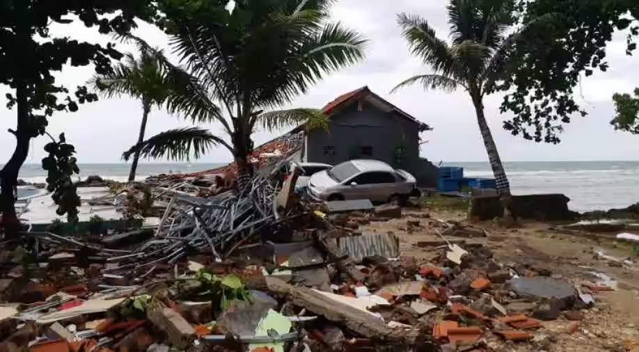
On the evening of February 8, 2025, a powerful magnitude 7.6 earthquake struck the Caribbean Sea, southwest of the Cayman Islands. Occurring at 6:23 p.m. local time, the quake’s epicenter was located approximately 130 miles south-southwest of George Town, Cayman Islands, at a depth of 10 kilometers. This significant seismic event prompted tsunami warnings across several nations in the region, including the Cayman Islands, Puerto Rico, the Dominican Republic, Honduras, and Cuba. Authorities in these areas urged coastal residents to move inland and seek higher ground as a precautionary measure.
Historical Context of Caribbean Earthquakes and Tsunamis
The Caribbean’s seismic history is marked by several notable earthquakes and tsunamis. Over the past 500 years, there have been ten confirmed earthquake-generated tsunamis in the Caribbean Basin, with four causing fatalities. An estimated 350 people in the region have lost their lives due to these events. While tsunamis have inflicted fewer losses compared to other natural hazards like hurricanes and volcanic activity, their impact can be equally devastating.
One of the most catastrophic events occurred on January 12, 2010, when a magnitude 7.0 earthquake struck Haiti. This disaster resulted in the deaths of over 220,000 people and left a lasting impact on the nation. The earthquake’s epicenter was near the town of Léogâne, approximately 25 kilometers west of the capital, Port-au-Prince. The tremor caused widespread destruction, and the subsequent tsunami further compounded the devastation.
Geological Factors Contributing to Seismic Activity
The Caribbean region’s vulnerability to earthquakes and tsunamis stems from its position at the convergence of major tectonic plates. The boundary between the North American plate and the Caribbean plate is particularly active, leading to frequent seismic disturbances. Movements along this boundary have historically caused large magnitude earthquakes and, in some cases, devastating tsunamis. The U.S. Geological Survey has an ongoing program to identify and map the faults in this region using various geophysical and geological methods to estimate the location and magnitude of potential earthquakes.
Preparedness and Mitigation Efforts
Given the region’s susceptibility to seismic events, preparedness and mitigation efforts are crucial. The University of the West Indies Seismic Research Centre (UWI-SRC) plays a pivotal role in monitoring and researching seismic activity in the Eastern Caribbean. They provide real-time data on earthquakes, volcanoes, and tsunamis, helping to inform and prepare the public.
In the aftermath of significant earthquakes, international collaborations have been established to better understand the underlying geological processes. For instance, researchers have conducted studies near Haiti to probe the seabed and gather data on fault lines responsible for past earthquakes. These efforts aim to improve seismic hazard assessments and inform future preparedness strategies.
The Importance of Public Awareness
Public awareness and education are vital components of disaster preparedness. Understanding the signs of an impending tsunami, such as the sudden retreat of the sea or unusual ocean behavior, can save lives. Communities are encouraged to have evacuation plans in place and to participate in regular drills. Schools and local organizations often collaborate with seismic research centers to disseminate information and conduct educational programs.
Challenges in Predicting Seismic Events
Despite advancements in seismic monitoring and research, predicting the exact timing and magnitude of earthquakes remains a challenge. The complex interactions between tectonic plates and the multitude of variables involved make precise predictions difficult. However, continuous monitoring and research contribute to better risk assessments and preparedness plans.
The Role of Technology in Monitoring
Advancements in technology have enhanced the ability to monitor seismic activity in real-time. Seismographs, ocean-bottom sensors, and satellite data provide valuable information that helps in understanding seismic events as they occur. This data is crucial for issuing timely warnings and coordinating emergency responses.
Community Resilience and Recovery
Building resilience in communities involves not only preparing for potential disasters but also having robust recovery plans in place. This includes ensuring that infrastructure is built to withstand seismic forces, establishing efficient communication channels for disseminating warnings, and providing support systems for affected individuals in the aftermath of an event.
Looking Ahead
As the Caribbean continues to experience seismic activity, ongoing research, public education, and infrastructure development remain key components in mitigating the impact of earthquakes and tsunamis. By understanding the region’s geological dynamics and fostering a culture of preparedness, the Caribbean can better navigate the challenges posed by its natural environment.
Frequently Asked Questions
What causes earthquakes in the Caribbean?
The Caribbean’s seismic activity is primarily due to its location at the boundary between the North American and Caribbean tectonic plates. The movements and interactions of these plates lead to stress accumulation and release in the form of earthquakes.
How common are tsunamis in the Caribbean?
While tsunamis are less frequent than other natural disasters in the Caribbean, they have occurred throughout history. In the past 500 years, there have been ten confirmed earthquake-generated tsunamis in the region, with four causing fatalities.
What should I do if I feel an earthquake near the coast?
If you experience strong shaking near the coast, it’s essential to move inland and to higher ground immediately, as an earthquake can trigger a caribbean earthquake tsunami. Listen to official communications and follow local authorities’ instructions.
Are there early warning systems for tsunamis in the Caribbean?
Yes, the Caribbean has established early warning caribbean earthquake tsunami systems to detect tsunamis. Organizations like the UWI Seismic Research Centre monitor seismic activity and provide alerts to help communities respond promptly.
How can communities prepare for earthquakes and tsunamis?
Communities can enhance preparedness by developing and practicing evacuation plans, building structures that adhere to seismic safety standards, and educating the public about the signs of tsunamis and appropriate responses during caribbean earthquake tsunami seismic events.
What role does international collaboration play in understanding Caribbean seismic activity?
League International collaboration is crucial for advancing research on seismic hazards in the Caribbean. Joint efforts, such as seabed studies near Haiti, help gather data on fault lines and improve seismic hazard assessments, ultimately contributing to better preparedness and mitigation strategies.
Black By staying informed and proactive, residents and visitors in the Caribbean can better protect themselves and their communities from the caribbean earthquake tsunami potential impacts of earthquakes and tsunamis.
To read more, Click Here